The Problem
One of the most significant barriers to effective collaboration and leveraging of past work is being able to access and share any tool or model output or analysis, within the transparent context of the inputs and methods from which it was produced (Wilkinson et al. 2016). “Just send me the data”, is rarely actually that simple. Plus, one of the hallmarks of scientific rigor is reproducibility.
Sharing is Expected… and Easier Today
Sharing used to be techncially difficult, but today is easy. Many great tools now exist for sharing data (typically as a zip file) to comply with open access and data sharing requirements:


However, it can be difficult to use those platforms to make riverscapes specific data more easily consumable, explorable and useful to your audiences. Especially given the complexity of so many riverscapes tools and workflows, “can you make the data available?” is an easy thing to coply with by uploading a zip file to one of the services above, but a very difficult thing to do properly. We assert the Riverscapes community desperately needs data standards and simple tools for more effective sharing of riverscapes-specific data (Fryirs et al. 2019).
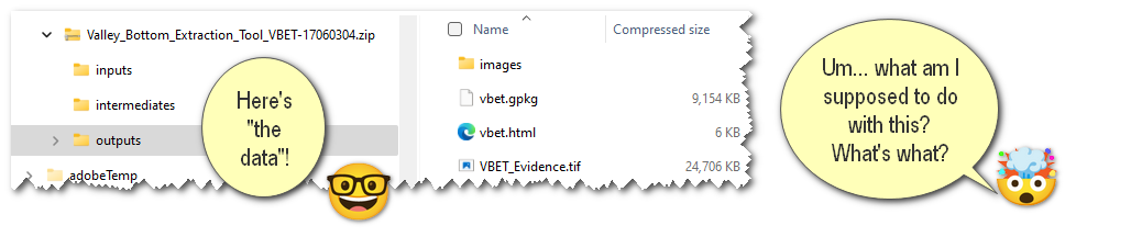
In an era of “big data”, it is easy to get overwhelmed without appropriate context. Unfortunately, context means metadata, and very few researchers and practitioners have the time or are likely to produce that metadata manually. However, failure to do so contributes to “dark knowledge” (censu Jeschke et al. 2019) through inaccessible data and information, and we can do better. We need to better leverage each other’s work, but we often do not because it is takes too much time.
A Better way for the Riverscapes Community
GOALS

- Make it easier to produce, curate and organize riverscapes analyses in the context of the inputs and intermediates they were produced from. - i.e. make exploreable in RAVE
- Foster transparency, reproducibility and sharing of riverscapes data and analyses.
- Simplify ability for tool users to make tool outputs F-A-I-R or at least F-A-R
To achieve the above goals, we propose packaging data as riverscapes projects  . This helps both the developer and the tool user grow their audiences for their tools
One way of achieve the third goal of packaging analyses as riverscapes projects is to facilitate the contribution of Riverscapes Data to a DATA Warehouses for sharing and achieve F-A-I-R. With our RAVE tools and Warehouse we strive to make it easy to contribute your data as a riverscapes project , which are:
There are many other platforms and warehouses where full or partial F-A-I-R can be achieved (e.g. zeondo, HydroShare, FigShare or OpenAIRE). These systems will not necessarily have awareness of what a riverscapes projects is, but they can handle uploading the data as a zip file, and at least the F, A and R parts of FAIR.
Note the F-A-I-R, correspond to the findable, accessible, interoperable and re-useable Principles (Wilkinson et al. 2016), which the RC strives towards and helps facilitate the riverscapes community follow.
Riverscapes Projects
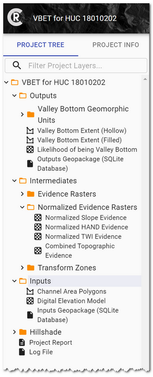 We developed a data standard for packaging up riverscapes analyses (i.e. outputs of any RC compliant tool into riverscapes projects . The project data can be navigated through a project tree like shown at right.
Riverscapes-compliant tools  automatically produce datasets that we call “projects”. Each project is accompanied by metadata documentation in the form of an XML project file. These project files have specific requirements and must comply with the riverscapes project schema. In addition, the projects have a simple, standardized folder structure in which all data files are saved and or modified to disc (I/O).
Riverscape projects can also be manually produced for any dataset and analysis to provide it context. For datasets that you want to share with a large audience, but may not produce that many times, it still may be worth the investment.
Overview Illustrated
This five minute video explains the basics of riverscapes projects.
What are the Benefits of Riverscapes Projects?
Beyond better organization and transparency, the major benefits of riverscapes projects are:
- Easy Visualization & Exploration in GIS & Web
- Easier to Share with Metadata
- Scalable Analyses & Interoperable with other Riverscapes Compliant Tools
Easy Visualization and Exploration in GIS and Web
Sharing and opening any project in the RV (Riverscapes Viewer). You can reach GIS audiences with RV in ArcGIS or QGIS, or non-GIS users through WebRV.
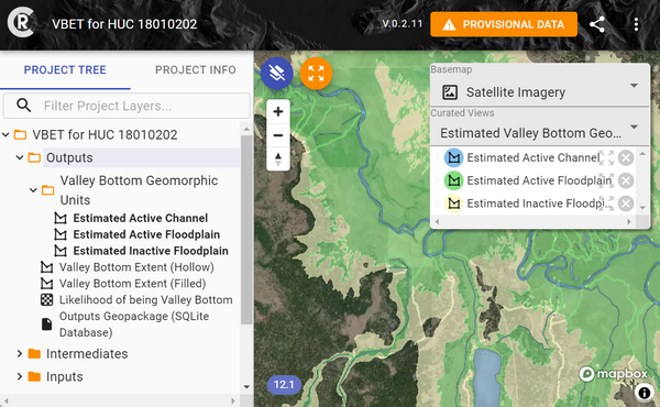
Example of WebRV view of a project. You can curate "Views" of collections of layers in your project, or they can add any layer to the map and see it symbolized as you intended it to be visualized. As the curator of your own project type, you can specify this symbology consistently.
Easier to Share with Metadata
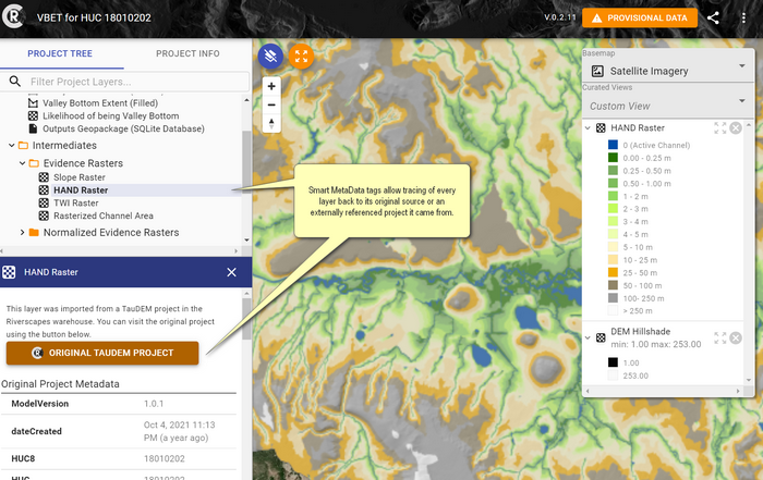
All layers have easily viewed Metadata from the Project Tree, which allows tracing back individual layers to their original sources or externally referenced projects.
 The packaging of data into a folder or zip file that can be easily shared, and then opened in any RV app is handy. It ensures that your audience will see the data organized as you want it to be, with the right context, and correct symbology.
Riverscapes projects can be stored in Riverscapes Warehouses and made publicly available. - Riverscapes projects in a warehouse can be discovered through websites, webGIS maps, APIs, web mapping tile services (e.g. WMS or WMST).
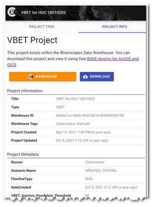
Moreover, Riverscapes Projects facilitate automated metadata production and housekeeping. An example of the automatically generated metadata for a production-grade, network tool is shown at left.
Scalable Analysis & Interoperability
Riverscapes projects can be accessed, modified and populated with cloud computing because querying, and batching operations are possible with a consistent data standard and storage. Plus, other riverscape-compliant projects can easily reference each other.
References
- Fryirs KA, Wheaton JM, Bizzi S, Williams R, Brierley GJ. 2019. To plug-in or not to plug-in? Geomorphic analysis of rivers using the River Styles Framework in an era of big data acquisition and automation. Wiley Interdisciplinary Reviews: Water 6 : e1372. DOI: 10.1002/wat2.1372
- Jeschke JM, Lokatis S, Bartram I, Tockner K. 2019. Knowledge in the dark: scientific challenges and ways forward. FACETS. DOI: 10.1139/facets-2019-0007
- Wilkinson MD et al. 2016. The FAIR Guiding Principles for scientific data management and stewardship. Scientific Data 3 : 160018. DOI: 10.1038/sdata.2016.18